


 The Australian Beach Boys Show
03 May 2026 - Renmark
 Kevin Bloody Wilson Aussie Icon Tour with special guest Jenny Talia
27 Mar 2026 - Renmark
 Ireland The Voyage
24 Feb 2026 - Renmark
 Cirque Nouvelle
14 Apr 2026 - Renmark
 Song Sung Blue. The Neil Diamond Experience featuring Troy Harrison. A Story in Every Song.
06 Mar 2026 - Renmark
Salinity and the Murray River
Related Information -
Links may change without notice
To understand where all the salt comes from, first you need to know that the Murray-Darling Basin was submerged under a shallow sea; so on a map it looked like a group of islands rather than its present shape. At that time the whole land mass started to rise out of the sea (about 100 million years ago). Salt water flowed away from the emerging land back into the ocean, and a river was born which would eventually become the present-day Murray (see the beginnings).
Throughout southern Australia today we are experiencing a wide-ranging and fundamental readjustment in environment. The land changes caused by European settlement has created the major manifestation of salinity throughout the landscape. As a consequence, rising water tables are bringing salt previously stored undisturbed to the surface where it affects soils, streams and vegetation causing widespread salinization.
The additional 200-600 mm of imported irrigation water on top of the normal 300-500 mm of rainfall inevitably causes water table rises and widespread salinization. It affects virtually all major irrigation areas. For instance, in Northern Victoria, the Loddon Valley has 250,000 hectares with shallow saline water tables. In the Goulburn irrigation area there is now about 120,000 hectares with shallow water tables; this area is expected to double in the next 40 years if nothing is done.
In the dryland areas, the effects are twofold, leading to both land and stream salinization. Virtually all streams in south western Victoria are brackish or saline due to groundwater out seepage, and this same process is now gradually affecting tributary systems feeding the major rivers of north western Victoria. The annual cost to Australia in lost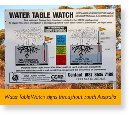 production alone is close to $100 million; the environmental cost can only be conjectured. In Victoria, the annual loss of $50 million per year will be doubled in the next 40 years if no solutions are found.
In the Kerang Irrigation District,Victoria and the Wakool Irrigation District of New South Wales, saline water tables are within capillary reach of the surface and salinity is a major problem. Similarly, groundwater pressure rises are occurring in the dryland highland areas, in the plains and in the Mallee. In the Mallee, rises in saline water tables are evident by salinization of depressions, stock dams and some roads.
In undulating settings in the Mallee and the highlands, the inevitable results of continuing water table rises is saline depressions or brackish to saline land and stream systems respectively. That is, under the present land-use techniques the trends in rising water will continue with the gradual expansion in land and stream salinization being inevitable and, in some cases, irreversible. The threats to agriculture where salinity is caused by rising groundwater pressures is a major issue for surface water supplies and agricultural land rendering the environment unusable.
Source: The Murray; Murray Darling Basin Authority
Salt Inception Schemes
| How do you test for Salinity? Salinty is a measurement of the concentration of salts in water. Technically, salinity is measured in Electrical Conductivity Units (ECU’s). The more salt in a solution, the more it conducts electricity. Electrical Conductivity Units |
|||
|
<50
|
Rainwater | ||
|
650
|
Salinity level can damage irrigated crops | ||
|
800
|
World Health Organisation standards consider this the maximum desirable limit for water quality | ||
|
>1500
|
Can’t be used for many crops Likely to cause direct damage to natural ecosystems | ||
|
>5000
|
No longer considered to be fresh water Most freshwater animals and fish won’t survive |
||
|
50,000
|
Seawater | ||
Picture a convoy of dump trucks carrying salt, pulling up and dropping their loads into the River Murray and you’ll get an idea of how much salt enters the River every day. Historically the areas around Waikerie and Woolpunda in South Australia contribute close to 350 tonnes of salt a day between them. In South Australia the development of salt interception schemes has reduced this figure by more than 85%. That’s over 300 tonnes of salt that is no longer going into the Murray every day. The inception schemes have lowered the average salinity at Morgan by 22 EC units.
How an inception scheme works? A system of bores and pumps take the highly saline groundwater from underground before it can enter the River. It is piped to the 400 hectare Stockyard Plain Disposal Basin 15 km south west of Waikerie. There the saline water is disposed of by evaporation and infiltration into the ground, and will not return to the River for thousands of years. The schemes are directly benefiting downstream of River Murray water. Irrigators in the immediate area are seeing the benefits of the lowered level of groundwater under their land, and healthy Murray flood-plain vegetation is beginning in some areas. Natural revegetation is also being encouraged around the basin near Waikerie - 135 species of birds now inhabit the area.
Source: SA Department of Water, Land and Biodiversity Conservation (pdf)

Tell your friends you found this at murrayriver.com.au!
Copyright Discover Murray 2026. This site or any portion of this site must not be reproduced, duplicated, copied, sold, resold, or otherwise exploited for any commercial purpose that is not expressly permitted by DISCOVER MURRAY.