


 An Afternoon Of Classical Piano
21 Oct 2023 - Renmark
 Angove Family Winemakers Art Exhibition featuring Wendy Neal
20 - 29 Oct 2023 - Renmark
03 Nov 2023 - Renmark
 Anh Do The Happiest Refugee Live!
30 Nov 2023 - Renmark Kiewa Street Markets
09 Sep - 31 Oct 2023 - Albury
Hattah on the Calder Highway between Mildura and Ouyen

Hattah Events
Check out what's going on|
|
Accommodation near Hattah:Mildura AccommodationRobinvale Accommodation Swan Hill Accommodation Euston Accommodation |
Hattah Photos
Courtesy of Murray River PhotosHattah Weather
Towns Near Hattah
Kyalite, Mildura, Ouyen, Robinvale, Red Cliffs, Irymple, Swan Hill, Boundary Bend, Wood Wood, Piangil, Walpeup, Euston, TooleybucExperience the significant Hattah Kulkyne National Park
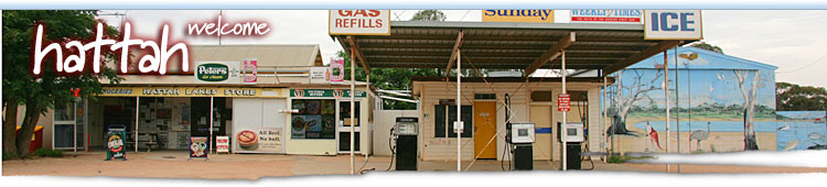
On the Calder Highway between Mildura and Ouyen, Hattah is a small town which is the gateway to significant Hattah Kulkyne National Park in the mallee.
Hattah-Kulkyne National Park and Murray-Kulkyne Parks provides that special quality of mallee country, the tranquil waters of the Hattah Lakes system and the Murray River. It features a series of lakes and billabongs which intermittently fill with flood waters from the Murray River and Chalka Creek. There are a series of local walks and drives to really experince the Hattah region.
Situated off the Murray Valley Highway 4 km east of Hattah, and 70 km south of Mildura, the parks have a combined area of 49 550 hectares. They occupy the area extending northwards from the Murray Valley Highway and parallel to and bordering the Calder Highway to the Murray River.
Surrounding the lakes Hattah, Tullamook, Marramook, Bulla, Arawak, Nip Nip and many more, creeks and along the Murray River are the river red gums. Black box are seen further away from the water; cypress-pine and bull-oak dominate the low ancient sand-dunes, while mallee dominates on the infertile sand-dunes and in the western section of the park. Within the park are three well-defined habitats - wetland, open woodland and mallee.
Mallee country is dominated by mallee eucalypt shrub. The shrubs have a number of stems growing from a large lignotuber or root (the famous mallee root) up to an average height of 6 m. The conditions are harsh: low rainfall, hot summers, cold nights, and infertile sandy soils are tough for plants and animals.
Wildlife includes red and western grey kangaroos, possums and echidnas. But it is the birdlife that makes the park special. Over 200 species have been recorded. On the waters of the lakes can be seen black swans, Australian pelicans, great-crested, hoary-headed and Australian grebes, darters, great, little black and little pied cormorants, maned geese, chestnut teals, hardheads, purple swamphens, black-winged stilt, black ducks, mountain and many other ducks.
The lake margins are home to white egrets, white-faced and white-necked herons, royal and yellow-billed spoonbills, white and straw-necked ibis, and birds of prey such as swamp and spotted harriers and sometimes the white-breasted sea-eagle. Wedge-tailed eagles are also sighted. The gnarled river gums with their many nesting hollows support countless galahs, regent, ringneck and mulga parrots, white and pink cockatoos. The open country is home to the energetic mound-builder the mallee fowl, noisy minors and white-winged choughs, while rufous-crowned emu-wrens and striated grass-wrens are found in the grasslands. Best viewing times for the birds and animals are early mornings and at dusk.
Hattah park walks and nature drives
A short 1.2 km self-guided nature walk begins at the park entrance. Description pamphlets are available at the information centre/office.
Lake Nip Nip Walk
Distance: 5 km from visitors' centre. From Lake Hattah proceed east across the embankment and follow the track passing the northern shores of lakes Bulla, Brockie and Tullamook. Lake Nip Nip is the next lake. Late in the afternoon kangaroos and emus can be seen along with regent parrots and galahs.
Calder Highway Walk
In the area of the park bounded by the Old Calder Highway, Ouyen Highway and to the north of the Murray Valley Highway is a convenient area to bird-watch, in that there is little chance of getting lost. There are few defined tracks. The vegetation is that of mallee in pristine condition, which supports mallee fowl, mallee ringneck parrots, crested bellbirds, splendid and variegated fairy-wrens, brown-headed honeyeaters and thornbills. The mallee is best viewed during winter and spring.
Camel Pad Walk
Designed for visitors without a vehicle, the walk begins near the electricity substation 200 m north of the Hattah store on the Calder Highway. Follow the markers to the fire break and continue on it for 800 m then turn east onto Camel Pad Track. The track passes a salt pan and then joins the Old Calder Highway. Continue (500 m) along the old highway to Woodlands Gate. The fence here was erected to contain the movement of western grey kangaroos. Cross the fence by means of the stile and continue 3.8 km to Buloke Track. Follow Buloke track for about 500 m to the "T" intersection. The northern route leads to Lake Mournpall (1 km) and the southern route leads to Hattah Lake (8.5 km) along the Hattah-Mournpall Track.
Hattah Nature Drive
Distance: 6 km. Time: approx 30 minutes. This pleasant drive has been designed to show the visitor some of the natural features such as the lakes, sand-dunes, the river red gums, stands of black box, bird and wildlife. Pamphlets are available at the information centre/office.
Lake Mournpall Drive
Distance: 18km return. This drive takes you through more open country where you pass stands of casuarina and vegetated sand-dunes. Lake Mournpall is the location of the second camping area in the park.
Explore Hattah
Expand Map
Tell your friends you found this at murrayriver.com.au!
Copyright Discover Murray 2025. This site or any portion of this site must not be reproduced, duplicated, copied, sold, resold, or otherwise exploited for any commercial purpose that is not expressly permitted by DISCOVER MURRAY.