


 Ireland The Voyage
24 Feb 2026 - Renmark
 Kevin Bloody Wilson Aussie Icon Tour with special guest Jenny Talia
27 Mar 2026 - Renmark
 Cirque Nouvelle
14 Apr 2026 - Renmark
 The Australian Beach Boys Show
03 May 2026 - Renmark
 Lewis Major: Triptych
14 Mar 2026 - Renmark
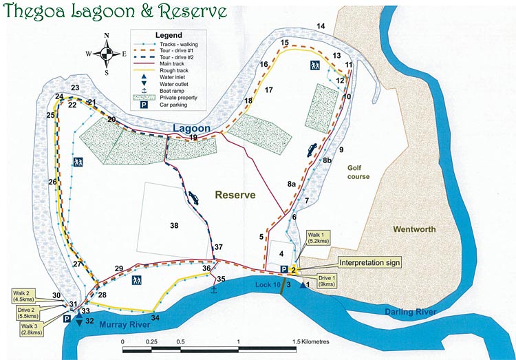
Thegoa Lagoon & Reserve, Wentworth, New South Wales

Wentworth Events
Check out what's going onWentworth Restaurants & Food
Find a place to eatWentworth Arts & Culture
Experience the regions unique artsWentworth Tours & Touring
Experience the region's local storyWentworth Council
Local Council/Shire in this areaWentworth Heritage & Historic
Our rich and unique river historyWentworth Attractions and Activities
Plenty to see, do and experienceWentworth Cafe
Enjoy a great coffee here!|
|
Accommodation near Wentworth:Euston Accommodation |
Wentworth Photos
Courtesy of Murray River PhotosWentworth Weather
Towns Near Wentworth
Mildura, Dareton, Renmark, Customs House, Robinvale, Red Cliffs, Merbein, Nangiloc, Ouyen, Meringur, Cullulleraine, Werrimull, Gol Gol, Buronga, Euston, Curlwaa, Pooncarie, Broken Hill
Thegoa Lagoon Management Committee gives many thanks to the NSW Murray Wetlands Working Group and Barkindji Elders Council for their valuable advice, guidance and support.
Thegoa Lagoon Management Committee has made every attempt to ensure the accuracy of the information in this brochure and accepts no responsibility or liability for omissions or incorrect information.
In 2003, the Thegoa Lagoon Management Plan was developed in response to the need for an integrated and long term approach for the rehabilitation and conservation of this precious and vulnerable resource. The Thegoa Lagoon Management Committee meets regularly to direct and monitor the progress of the actions detailed in the Plan.
Background
Description
Thegoa Lagoon is an ephemeral (non-permanent) freshwater wetland that supports a healthy and diverse array of native flora and fauna. It is an important cultural, social and economic resource to Wentworth and the Lower Murray Darling region.
Location
Thegoa is adjacent to the historic Murray River and Darling River junction in Wentworth, NSW.
Size
The lagoon is approximately 30 metres above sea level with a surface area of around 80 hectares and a capacity of more than 600 Megalitres. The floodplain Reserve bordered covers approximately 445 hectares.
Boundaries and sites
Thegoa Reserve’s southern boundary lies along the Murray River from the Weir and Lock 10 to the Lagoon’s western inlet. The western and north-east area contains major Aboriginal heritage sites and includes walking tracks. The north-east section also includes private lease holdings. The central area holds the water treatment plant (scheduled for relocation) and the Wentworth cemetery.
Name origins
The name ‘Thegoa’ is thought to have originated from the Aboriginal language. Government surveyor Francis MacCabe, who surveyed the area, first recorded the name in 1850. MacCabe employed Aboriginal people in order to follow Surveyor-General Thomas Mitchell's instructions to record Aboriginal placenames wherever possible.
Current uses
Thegoa Lagoon and Reserve is used by a wide variety of users for many diverse purposes. Land use in the immediate environment includes irrigation, grazing, horticulture, public open space recreation, residential, commercial accommodation, cemetery, water treatment plant and Crown Reserve. The lagoon provides water for irrigation, recreation, stock and domestic use, and environmental benefits.
There are four distinct ecologically significant vegetation communities: Riparian Open Forest (River Red Gum and River Cooba), Open Woodland (Black Box and River Cooba), Chenopod Shrubland (Old Man Saltbush with scattered Black Box) and Instream Aquatic (Cumbungi and Ribbon Weed). Each community has an understorey of distinct shrub and groundcover species. One locally common species Desert Glasswort (Pachycornia triandra) is listed as having a restricted regional distribution.
Cultural Significance
Aboriginal Heritage
Aboriginal people - Welcome to Country
The Aboriginal people living along the Darling River, called the river the Barka (or Paaka) hence their name, Barkindji (or Paakantyi), meaning ‘belonging to the river’.
Meeting place
Thegoa was an important meeting place due to its proximity to the junction of the Murray and Darling Rivers. The last great corroboree of a group of over 500 Aboriginal people was held in the 1860s, although many smaller gatherings were still held after this date.
Bush tucker
During and following floods, the lagoon would have provided abundant wildlife, fish and plant material for use by local Aboriginal people. Aboriginal bush tucker includes plants like nardoo, cumbungi and ruby salt bush; and animals such as kangaroos, lizards, yabbies, mussels and native fish. The sugary ‘fairy floss’ produced on Eucalypt leaves by tiny insects called ‘lerps’ was eaten as a treat.
Aboriginal archaeological sites
The area contains numerous sites indicating Aboriginal inhabitation. These sites have been assessed as having a moderate to high archaeological scientific significance due to their representativeness and preservation. All of the sites remain significant to Barkindji Elders and the Barkindji community. Sites include:
- Middens - these are where Aboriginal people discarded their food scraps, which included the mussel shells remaining today.
- Hearths - there is evidence of campfires or hearths.
- Scar trees - canoes, shields, coolamons (bowls) and other tools were cut from the bark of mostly River Red Gum trees.
- Boundary/Marker trees - these trees are a remarkable living example of Aboriginal expertise. It is thought two branches were grafted together to create a circle, perhaps marking a boundary or providing a place for an offering.
Site Description
|
1. Inlet This inlet regulator was installed in 1956 and is used to let water into the Lagoon. 2. Interpretation board – opposite Lock 10. 3. Lock 10 and Wentworth Weir – built in 1929. 4. Wentworth Cemetery – where many local pioneers are buried. 5. Old rubbish dump – reclaimed in 2005 as part of the Thegoa Lagoon Management Plan. 6. Bridge – walking access to Golf Course. 7. Lagoon bed - Shallow sections of the Lagoon flood and dry frequently and can support a diverse range of native wetland plants (including Cumbungi, Nardoo and Azolla). When flooded, frogs, invertebrates and wading birds are abundant. 8. Vegetation communities a. Chenopod scrubland on left side: The Chenopod Shrubland is characterised by plants in the family Chenopodiaceae. Plants include Saltbush (Atriplex spp., Rhagodia spp. and Enchyleana spp.), Bluebush (Maireana spp.), Copperburr, Poverty Bush and Roly Poly (Sclerolaena spp.). Black Box on the right side: Black Box (Eucalyptus largiflorens) grows here with a remnant saltbush understorey. Black Box are adapted to survive droughts, slight salinity and inundation better than other ‘Box’ trees. Seedlings appear after flooding but generally only establish over a narrow belt along the high water line of the flood in which they germinated. Hence the clear rows of Black box. River Cooba on the right side: River Cooba (Acacia stenophylla), also called River Myall or Ironwood, is common at Thegoa, growing on heavy clay soils along the lagoon banks. It is an attractive tree with a weeping habit that flowers in summer to early autumn. After an inundation of the Lagoon, seedlings may be abundant along the flood-line but only a few survive. b. River Red Gums (Eucalyptus camaldulensis) are the most common trees along the rivers and streams of the Murray Darling Basin. The red in the name derives from the colour of the heavy, durable timber, which has had many uses including riverboat fuel, wharf pilings, railway sleepers, construction, furniture, canoes, bowls and shields. 9. Levee bank The levee bank construction began in the 1880’s to protect Wentworth from floodwaters of the Murray and Darling Rivers. Further work was done against the 1930 and 1956 floods. 10. Aboriginal site – shell midden (many pieces of mussel shell). 11. Picnic spot – roll out a picnic blanket and enjoy the wetland. 12. Aboriginal site – scar trees (coolamons/bowls?). 13. Aboriginal site – boundary/marker tree. 14. Old Wentworth racecourse – In the 1800s, horse racing was held just over the northern edge of Thegoa Lagoon before being moved to the current showgrounds site in 1880. The Wentworth Racing Club was known as one of the best in country NSW. |
15. River Red Gum regeneration – After an inundation of the Lagoon, seedlings may be abundant along the flood-line but only a very small number survive. 16. Cracking grey clay – As the name suggests, on drying this clay cracks deeply (up to one metre) and widely and is a good habitat for reptiles, small mammals and insects. 17. Lignum patch – Lignum (Muehlenbeckia florulenta) is a widespread plant that is a favoured breeding ground for wildfowl. 18. Ruby Saltbush (Enchylaena tomentosa) patch – Ruby Saltbush is a common perennial shrub with succulent yellow or red berries that were eaten by Aboriginals. The leaves may have been eaten sparingly as a green vegetable. 19. Great view – view over Lagoon (stable on left). 20. Aboriginal site – shell midden (many small pieces of mussel shell). 21. Aboriginal site – boundary/marker tree & old scar tree (canoe). 22. Darling lillies – a large perennial ‘lily’, Crinum flaccidum leaves appear in winter and strongly scented flowers appear in summer-autumn. 23. Deepest part of lagoon – up to 3 metres deep. Deeper areas of the Lagoon can support submerged plants like Ribbon Weed (Vallisneria americana). These deeper sections provide abundant food and habitat for animals such as turtles, yabbies, swans, ducks and various fish. 24. Picnic spot - lovely view over Lagoon. 25. Bird watching site – great spot to observe birds. 26. Aboriginal site – scar tree (small canoe or shield?). 27. Piezometers – used to measure groundwater conditions. 28. Aboriginal site – scar tree (canoe). 29. Log Bridge Road/Cadell St – the original road from Sydney to Adelaide. 30. Aboriginal site – scar tree (canoe) and shell midden. 31. Log Bridge - the bridge over the outlet/inlet. 32. Outlet/inlet – Water flows into and out of the Lagoon through this passage, under Log Bridge Road. 33. Aboriginal site – boundary/marker tree (look up high!). 34. Sandbar – great place to enjoy the Murray River. 35. Sand hopper – near the boat ramp, the sand hopper was used for sand extraction in the 1970s. 36. Aboriginal site – scar trees (are these coolamon scars or perhaps shields?). 37. Desert glasswort patch - Desert Glasswort (Pachycornia triandra) is an unusual plant, listed as having a restricted regional distribution. It grows well on saline clay soils. 38. Wentworth water treatment works. |
The Environment
Environmental values
Habitat value
Wetlands are highly productive and diverse biological systems providing wildlife habitat, that supports a unique array of plants and animals, including birds, insects, invertebrates, fish, amphibians, reptiles and mammals. Due to their high productivity, wetlands make a substantial contribution to food chains of both plant and animal species.
Water quality enhancement
Wetlands are important for the water quality of the river system as they buffer flood flows, filter nutrients and sediments, and provide native wildlife and fish habitat.
Recreation and tourism
Wetlands have significant recreational and scenic values, providing a setting for diverse recreational activities including bird watching, bush walking, horse riding, fishing and picnicking.
Environmental features
Natural flow regime
River regulation and a relatively high flooding frequency in the past has led to a misconception that wetlands such as Thegoa Lagoon are permanent water bodies. However, most Australian inland wetlands are adapted to periodic wetting and drying cycles which maintain ecological productivity and diversity. Thegoa is now managed to have wet and dry phases.
Soils
Soils within the Reserve and Lagoon are mainly silty non cracking clays as well as cracking grey clays. On drying, the cracking clays crack deeply (up to one metre). Small marble sized crumbs on the surface may form if accessed by sheep.
Vegetation
Thegoa has a high degree of floral diversity within a relatively small area, which is unusual for a small area that is so close to a residential area.
Water flow
Prior to regulation in 1929, Thegoa Lagoon naturally filled and dried according to periodic flooding of the river system. This regime sustained essential processes, which maintain biological productivity and environmental health.
1929 – Wentworth Weir and Lock 10
In 1929, the Wentworth Weir and Lock 10 were built. During high flows, water could still enter the lagoon via the downstream inlet but water was manually diverted to the upstream end of the lagoon.
1956 - the Great Flood
The natural wetting and drying cycle of the Lagoon was further altered after the 1956 flood, when a 300mm pipe was installed under Cadell Street to create a permanent water connection between the Lagoon and the Murray River.
Blocking the Darling inlet
In the 1950s the Darling River inlet at the north-eastern end of Thegoa Lagoon was filled in to facilitate road and building development, further altering Thegoa Lagoon.
1969 - larger pipe at inlet
The 300mm under Cadell Street pipe was replaced in 1969 by a 600mm pipe. From 1970 to 1996, water entering the Lagoon was regulated to maintain a relatively constant level.
1980 - slide regulator
In 1980, a metal slide regulator was installed at the Cadell St inlet to retain even higher levels of water in the Lagoon.
1996 - more natural regime
Since 1996 regulated flows have been prevented from entering the Lagoon, aiming to establish a more natural hydrological regime to return the biological biodiversity of the Lagoon. Environmental flows are applied when deemed appropriate.
Animals
Animals observed at Thegoa Lagoon include four native fauna species that are listed as threatened and 14 species that are listed as vulnerable and rare in the National Parks and Wildlife Regulations.
Birds
More than 100 species of birds have been observed in the Reserve, of which (in 2005) three native bird species were listed as threatened and 10 were listed as vulnerable and rare.
Mammals
Native mammals observed at Thegoa include echidnas, brush-tail possums, bats and western red and eastern grey kangaroos. However, there are also feral and exotic animals present including feral cats, foxes and rabbits.
Amphibious Fauna
Several different frog species have been identified at Thegoa (including the Plains Froglet – Crinia parinsignifera and the Eastern Banjo Frog – Limnodynastes dumerilii). These frogs are common within the Lower Murray Darling area.
Aquatic Fauna
Aquatic fauna in Thegoa Lagoon includes water rats, mussels, turtles, exotic and native fish (including Gudgeons – Hypseleotris spp., Golden Perch – Macquaria ambigua and Australian smelt – Retropinna semoni). Fishing is a passive recreational activity undertaken by both locals and visitors. Yabbies are present depending on season and water flow.
Reptiles
Lizards observed in Thegoa Lagoon include shingle back lizards, bearded dragons, lace monitors and goannas.
Post-European Settlement Heritage
Historical Names
Loggy Bridge Road was the original name for the road along the Murray River, which is one of the oldest roads in the Wentworth area. It was used in the 1840s as the main road between Sydney and Adelaide. Log Bridge was constructed over the Lagoon’s outlet.
Although Thegoa Lagoon was always the official name, locals called it ‘The Billabong’. The floodplain was known as the ‘Wentworth Common’ from the late 1800s until 1956.
TSR and Stock Reserve
From the mid-1800s, Thegoa Reserve was a Stock Reserve and part of a Travelling Stock Route with overlanders droving over 150,000 head of stock through in a year. In the 1850s travelling stock numbers declined as settlers took up land along the TSR and the route changed.
The ‘Wentworth Common’
From the 1880s to 1956, the Reserve was called the ‘Wentworth Common’ and used for stock agistment (cattle, horses, goats and sheep). Commons were notoriously overgrazed.
Lock 10 construction
A large workers’ camp was set up on the Reserve near the current cemetery during construction of the Weir and Lock 10 in 1929. Building resources were obtained locally with large amounts of timber and sand taken from within the Reserve. Within the Reserve are old building foundations, fence lines, rubbish and bottle dumps, crockery remnants and shelters.
Quarry
Soil was quarried from Thegoa Reserve during desperate measures to build a levee bank during the 1956 flood.
Sand harvesting
The Sand hopper near the sandbar was used in the late 1960s to the 1970s to harvest sand from what was a huge sand bar, for use in cement.
Cemetery
The Wentworth cemetery, where many of the district’s pioneers are buried, is in Thegoa Reserve opposite Lock 10. In the past, the cemetery was separated from the town during floods so funerals had to be boated in.
Revegetation site
Until 2004, there was a rubbish dump on the southern part of the Reserve but this was reclaimed and revegetated as part of the Thegoa Lagoon Management Plan.

Tell your friends you found this at murrayriver.com.au!
Copyright Discover Murray 2026. This site or any portion of this site must not be reproduced, duplicated, copied, sold, resold, or otherwise exploited for any commercial purpose that is not expressly permitted by DISCOVER MURRAY.