


 The Italian Tenors
09 Apr 2026 - Renmark
 Cirque Nouvelle
14 Apr 2026 - Renmark
 Ireland The Voyage
24 Feb 2026 - Renmark
 Song Sung Blue. The Neil Diamond Experience featuring Troy Harrison. A Story in Every Song.
06 Mar 2026 - Renmark
 Lewis Major: Triptych
14 Mar 2026 - Renmark
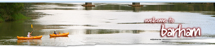
Barham NSW and Koondrook VIC a great spot to escape

Barham Town Guide
Contact the Visitor Information Centre
Barham Events
Check out what's going onBarham Photos
Courtesy of Murray River PhotosBarham Weather
Towns Near Barham
Koondrook, Echuca, Cohuna, Leitchville, Gunbower, Kerang, Lake Boga, Swan Hill, Murrabit, Lake Charm, Moama, Mathoura, Barmah, Wakool, Murray Downs
Great little spot on the river
 Located on the northern side of the Murray River, the NSW town of Barham and its Victorian partner on the other side, Koondrook, form the commercial centre for the region's, fat-lamb, cattle, cropping and dairy producers. You can catch the mood of the Murray with a leisurely stroll along the Redgum Statue River Walk, test your golf on a championship course, picnic on the banks of the Barham Lakes Park.
Barham is best known for its citrus groves, fishing, and/or relaxing at the man-made lakes on the river's edge. The twin towns service the extensive pastoral and horticultural regions, but they are also adapting to the increasing demands of tourists. Just out of town are the extensive river red gum forests of Koondrook and Perricoota.
This part of the Murray rewards anglers with the odd Murray Cod, golden perch, silverfish and catfish, while dobbers can land some very tasty yabbies. A track through the caravan park leads to a boat ramp and sand bar which form a safe swimming hole. Further on, Riverside Park is a popular picnicking area.
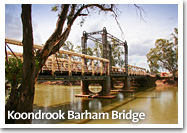
 For many years the twin towns were important trading stops on the river-boat journeys and also developed sawmills which provided red gum sleepers for the Victorian Railways. Koondrook developed faster than Barham, which was more isolated, until the towns were linked by the bridge over the Murray in 1904. A number of paddle steamers and barges were built from locally milled red gum.
Beyond the wetlands is Kow Swamp, where in the late 1960s anthropologists uncovered 13,000-year-old fossilised bones. Evidence that at least two distinct Aboriginal clans had colonised Australia.
The history of these towns dates back to the early expansion of the pastoralists. In 1843 Edward Green took up 54 000 hectares of land in NSW naming it 'Barham'. While across the river in Victoria, the Gunnawarra Run was established. Koondrook eventually was settled by farmers about 1881.
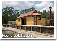 The development was hastened by the 26 km Kerang-Koondrook Tramway, built in 1889, which linked the river port of Koondrook with Melbourne via the railway link to Kerang. It was called a 'tramway' because only light rails were used. The tramway was not fenced in, nor were signals allowed. The line operated until 1976 for passengers and 1978 for goods. Competition from a sealed road to Kerang reduced its business and forced its closure. The old station remains in the middle of the main street, together with a replica of one of the last locomotives used on the line.
Things to see and do in Barham and Koondrook
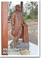
The Koondrook Barham Redgum Statue River Walk commenced in November 2002 with the carving of Alexander "Sandy" Arbuthnot. The carvings depict wildlife and local people who are significant to the region. The walk continues to be a work in progress with the addition of new sculptures each year. Redgum sculptures are carved by chainsaw by Kevin Guilders, a world renowned chainsaw carver from Melbourne, who has produced most of the sculptures in the Walk.
Koondrook Track, Gunbower Island: The road south leads through 'Victoria's Kakadu', the Gannawarra wetlands which support nearly 160 different species of birds and countless numbers of native fauna.
Barham Lakes East Barham Road. This is a wonderful 32 hectare lake complex constructed by the Barham Services Club. It includes sheltered picnic areas, playgrounds, barbecues, making it an ideal spot for a restful break. There are also wide expanses of lawn, 4.5 km of cycling/walking tracks and the lake system is stocked with native fish.
Murrabit: A 25km drive north-east takes you to Murrabit which hosts a celebrated market on the first Saturday of every month.
Forest drives around Barham and Koondrook
From Barham scenic drives may be taken through three nearby areas of natural bushland.
Gunbower Island State Forest, just a short drive from Koondrook/Barham, the State Forest is a sanctuary for birds and native mammals and has a circuit walk that takes most of the day to complete.
Campbells Island, near Murrabit, is bound by the Murray and Little Murray rivers, and an ideal location for fishing, swimming and boating.
Koondrook State Forest has excellent camping spots on the banks of the Murray and good fishing.
Koondrook | Swan Hill (Down River) - Kerang | Cohuna (Up River)
|
Wakook Shire Council |
Explore Barham
Expand Map
Tell your friends you found this at murrayriver.com.au!
Copyright Discover Murray 2026. This site or any portion of this site must not be reproduced, duplicated, copied, sold, resold, or otherwise exploited for any commercial purpose that is not expressly permitted by DISCOVER MURRAY.