


 Angove Family Winemakers Art Exhibition featuring Wendy Neal
20 - 29 Oct 2023 - Renmark
 CREEDENCE CLEARWATER COLLECTIVE
11 Nov 2023 - Renmark
 DREAMS FLEETWOOD MAC & STEVIE NICKS SHOW
22 Oct 2023 - Renmark
 The Royal Edinburgh Military Tattoo 2023 - Arts On Screen
14 Oct 2023 - Renmark Kiewa Street Markets
09 Sep - 31 Oct 2023 - Albury
Barmah, VIC is next to the largest Red Gum forest in the world

Barmah on the Murray River -
Wetlands of International Importance
The township of Barmah sits on the banks of the Murray River, on a very picturesque river bend.
Situated approximately 230km north of Melbourne, Barmah is best known as the gateway to the Barmah National Park. Barmah is the only town in Victoria which is north of the Murray River, and is a wonderful area for camping, canoeing, bushwalking, fishing or enjoying a Kingfisher river cruise.
The Barmah National Park is heritage listed and home to the largest stand of River Red Gums in the world. The oldest River Red Gums are over 500 years old and often grow to thirty metres in height. The narrowest section or “choke” of the Murray River is upstream of Barmah, bounded on either side by the Moira and Barmah lakes.
The Barmah National Park has a fascinating history that can be explored at the Barmah Forest Heritage & Education Centre in Nathalia.
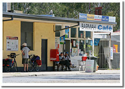 Local Barmah shop |
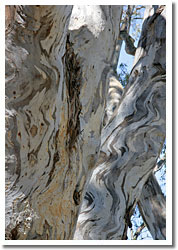 Beautiful textures of river red gums at Barmah |
Barmah National Park
Off the Murray Valley Highway towards the west at Picola-Katunga Road you'll find the township of Barmah. Take the Moira Lakes Road, next to the Barmah Hotel, for 9 km, to the edge of the forest and then follow Sandridge Track to the Dharnya Centre and cattle muster yards.
Barmah National Park together with the adjoining Millewa Forest in New South Wales forms the largest River Red Gum forest in the world. The complex ecology of the forest is closely linked to the Murray River and its flooding regime, creating a diverse natural habitat for a variety of wildlife, particularly waterbirds.
The Barmah – Millewa forest (River Red Gums National Park) is an internationally recognised wetland under the Ramsar convention and represents all four freshwater wetland types in Victoria. It is home to 220 species of birds, 35 species of mammals, 28 species of fish, 20 species of reptiles, 10 species of amphibians, and an unconfirmed number of inverebrates such as insects and up to 550 species of plants.it is also the last know nesting place of the Superb Parrot.
Visitors wishing to experience the unique forest and streams of the Barmah National Park may travel on graded tracks by foot, bicycle or motor vehicle.
Access can be gained from the Murray Valley Highway and Picola North Road, leaving the Murray Valley Highway at Yielima. Almost all roads north lead to river access tracks between Strathmerton in the East and Barmah in the West.
Park visitors coming over the bridge at the Barmah township should turn at the hotel and follow the Moira Lakes Road, past Barmah Island, a State Park, suitable for walking and camping and where dogs are allowed.
Camping and Wetland Kingfisher Cruise
The sealed road leads to the Barmah National Park Day area and camping ground. The Kingfisher River Cruise leaves from the day area, facilities are available for camping. Wetland tours of the Barmah Forest are conducted on Kingfisher, a 32-seater punt that takes visitors through the Barmah Forest lakes and creeks. Kingfisher Cruises (2 hours duration) departs Barmah Lake Day Visitor Area Sunday, Monday, Wednesday, Thursday and Saturday Minimum numbers apply bookings essential, groups by arrangement. Telephone (03) 5855 2855
Bush walking
A series of Barmah Walks have been developed close by the Dharnya Centre on Sandridge Track that are flat and easy walking. Always carry water. The walks are Lakes Loop 4.5 km, 2 hours, Broken Creek Walk 7.5 km, 3.5 hours and Steamer Plain Track 5 km 2 hours.
The heritage listed cattleyards can also be found near the Dharnya Centre. See the Cattlemen’s memorial which tells the historic stories of cattle agistment in the Barmah Forest. There is also a memorial log to commemorate the Forest Commission Officers.
Flat-water Canoeing
Morgans Beach to Barmah township: The Murray can be entered at Morgans Beach, some 56 km east of Barmah. Take the Murray Valley Highway and turn off to the left. car ferry This section of river offers the flat-water canoeist a wonderful glimpse of Australia's wildlife and is best taken when the river is high during the summer months.
Morgans Beach to Picnic Point: The first stage between Morgans Beach and Picnic Point, a holiday resort in New South Wales, takes about 2 days (12 hours) paddling. There are numerous creeks and backwaters which give better access to view the wildlife. Numerous camping sites are available. However, keep a sharp look out for snakes.
Picnic Point to Barmah Lakes: A half days paddling (3 hours) from Picnic Point brings you to the Barmah Lakes. The Moira Lakes on the northern bank of the Murray are in New South Wales.
Barmah Lakes to Barmah Township: A further 3 hours paddling downstream brings you to Barmah Township. Here the river widens and the river banks increase in height.
Aboriginal people
The Yorta Yorta people have a long association with the Forest. Scarred trees, mounds, stone artefact scatters, middens and burial sites can be found in the park.
Dharnya, on Sand Ridge Track near Barmah, is a significant place where you can see evidence of Indigenous living as well as European settlement, Interpretative signage as well as a fire pit, flagpole, picnic facilities and more make this the perfect place to learn about the heritage and ecology of the forest as well as enjoy Indigenous events and celebrations.
Aboriginal Cultural Officers can provide interpretative tours of the forest for schools and other groups. Call Parks Victoria on 13 19 63 for bookings
Barmah Heritage and Education Centre
Visit the Barmah Forest Heritage and Education Centre in Nathalia to discover and explore the colourful history of the Barmah National Park. Learn about the fascinating and diverse history of this iconic region and be amazed at the struggles of our forefathers, from prehistory to the present day. Stories are told in an easy going style that educates and enlightens. The centre is a great resource for schools, education groups and tour groups, with a video room available.
Catering for morning or afternoon tea is available on request. Telephone the centre on (03) 5866 2289 or contact us via email.
Facilities and Accommodation
The Barmah Lakes area has toilets, fireplaces and tables. Dispersed camping is permitted elsewhere along the river, with basic facilities at Ulupna Island. Nearby Barmah, Nathalia and Strathmerton have motels, hotels and caravan parks. Supplies and petrol are available at these centres.
Local Services
- Supplies
- Fuel/Car Repairs
- Caravan Parks
- Café and Hotel
Distances
Must see and Do
- Barmah National Park
- Kingfisher River Cruise-Nature and Ecotourism Accredited
- Camping Murray River
- Walking tracks, cattle muster yards, Dharnya Centre
- Yenbena Aboriginal Training Centre
Events
- Barmah Muster
Towns close by down river: Echuca Moama, Barham, Koondrook
Towns close by up river: Mathoura, Tocumwal, Deniliquin, Cobram, Barooga, Nathalia
Explore Barmah
Expand Map
Tell your friends you found this at murrayriver.com.au!
Copyright Discover Murray 2025. This site or any portion of this site must not be reproduced, duplicated, copied, sold, resold, or otherwise exploited for any commercial purpose that is not expressly permitted by DISCOVER MURRAY.